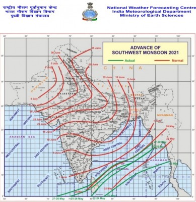
New Delhi, The monsoon onset over Kerala has been delayed by a few days and is now likely to take place on June 3 as the southwesterly winds gradually further strengthen from Tuesday resulting in likely enhancement of rainfall activity, latest meteorological indications show.
In the last five years, except for 2017 and 2018 (May 30 and 29 respectively), the monsoon has always been delayed by a few days. In 2020, it was forecast to hit on June 1, but it started on June 5; in 2019, it was predicted June 6, but it started on June 8 and in 2016, it was delayed by a day on June 8.
As per the India Meteorological Department's (IMD) Monday morning report, the northern limit of southwest monsoon continues to pass through 5 degree north and 72 degree east, 6 degree N and 75 degree E, 8 degree N and 80 degree E, 12 degree N and 85 degree E, 14 degree N and 90 degree E and 17 degree N and 94 degree E.
Due to strengthening of lower-level southwesterly winds, fairly widespread to widespread rainfall activity with isolated heavy falls is very likely over northeastern states during next five days, the IMD said.
The weather department reasoned Western Disturbance behind these changes considering a trough in mid and upper tropospheric westerlies with its axis at 5.8 km above mean sea level roughly along longitude 72 degree E to the north of latitude 30 degree N.
Lower-level moisture incursion from north Arabian Sea to the plains of northwest India taking place and is very likely to continue during next 3-4 days, the IMD further said.
Under its influence, the weather department said, no significant change in maximum temperatures is very likely during next five days. "Also, isolated to scattered rainfall and thunderstorm activity likely over Western Himalayan Region and adjoining plains of Northwest India during next 4-5 days."
The cyclonic circulation over east central Arabian Sea off Karnataka coast at 3.1 km above mean sea level persists and is likely to meander over the region during next five days, the IMD said.
"Southwesterly winds are also likely to strengthen during next 2-3 days."
Under the influence of these and other favourable meteorological conditions, the IMD further said, scattered to fairly widespread rainfall or thunderstorm is expected over Karnataka, Kerala and Mahe and isolated to scattered rainfall or thunderstorm over remaining parts of south Peninsular India during next 4-5 days.
Isolated heavy rainfall is also likely over Kerala and Mahe during next 5 days, the IMD said, adding the rainfall is likely over coastal Karnataka on June 1-3 and South Interior Karnataka on June 2-3.
Besides, the weather outlook for June 5-7 also forecast fairly widespread to widespread rainfall and thunderstorms with heavy rainfall at isolated places likely over northeast India.
"Scattered to fairly widespread rainfall and thunderstorms with isolated heavy falls likely over Peninsular India. Isolated to scattered rainfall and thunderstorms likely over East and Central India, Western Himalayan Region and adjoining plains of Northwest India."
However, the IMD said, weather is likely to be dry over remaining parts of the country.


.jpeg)

