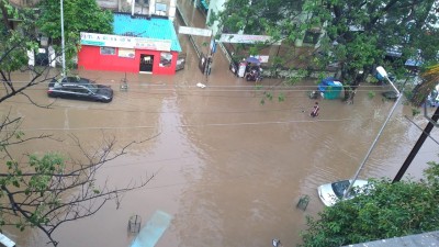
New Delhi/Mumbai, When mediapersons wanted to know the response of the Maharashtra government on Friday after massive landslides killed more than 40 people with several districts witnessing extreme rainfall and floods, Chief Minister Uddhav Thackeray said that there is a need to change the definitions of the terms used by the weather department.
"I have been taking stock of the situation for the last 4-5 days. Whatever forecast that the weather department had made, going by that we will need to change the definitions. It said 'ativrishti' (extremely heady rainfall), but there was no upper limit. It is raining beyond 'extremely heavy rainfall'. This is an unexpected disaster. There are landslides, flood waters are increasing, rivers are swelling and we are facing such extreme disasters," Thackeray told mediapersons in Mumbai.
The India Meteorological Department (IMD) uses the term 'Heavy Rain' for 64.5 to 115.5 mm rainfall; 'Very Heavy Rain' for 115.6 to 204.4 mm and 'Extremely Heavy Rain' for all rainfall more than 204.4 mm.
Some places such as Mahabaleshwar in Maharashtra or Agumbe in Karnataka or for that matter Cherrapunji in Meghalaya are known to have record rainfalls in the range of 40 to 60 cm (400 mm to 600 mm) on a given day. But for other places, it is for the IMD to forecast accurately and that is where the definitions fall short.
So what is the missing factor?
Mahesh Narvekar, Director, Disaster Management, Brihanmumbai Municipal Corporation (BMC), pointed at that the need for a proper early warning for preventing loss of life or property.
"Any kind of Disaster Risk Reduction (DRR) measures or Disaster Risk Management (DRM) efforts will need proper early warnings. But this early warning is dependent on proper forecasting," Narvekar said.
The financial capital of India faced extreme rainfall on Saturday (July 17), similar to what the Konkan region and several places across the Western Ghats have been facing.
Narvekar cited the example from north Mumbai wherein at 1 p.m., the IMD issued a yellow alert (heavy rainfall, up to 115 mm), "but about 12 hours later, it rained so much that it could have qualified as cloudburst. Why cannot they tell us one hour before about this extreme rainfall?"
He said because of the heavy rainfall that night, the water level in Mithi River raised from 1.80m to 4.2m. "At 3 a.m., the IMD NowCast said extremely heavy rainfall. But the rainfall stopped at 4 a.m.," he said.
The IMD has been constantly attacked for such misses by the local media, but Thackeray's remarks have put the agency in a different predicament.
"Thackeray's concern is well taken. But if we look at the science, it is not possible with reasonable accuracy to say that in such a particular place, there will be rainfall of 30 cm or 40 cm," IMD's Director General (Meteorology) Mrutyunjay Mohapatra told IANS.
The IMD deploys Doppler radar and satellite images that give observational data, which means they can tell what has happened. But forecast comes from the models. These models we go on improving year-wise and every year, he said.
Even with the state-of-the-art models that are presently used by the meteorologists, not just in India but across the world, it is a problem to deterministically determine the centimetre rainfall such as 30 cm or 40 cm (or for that matter, even more), Mohapatra claimed.
There has been an observed increase in natural disasters like cyclones and floods in the country during recent years, in many cases due to climate change. The frequency of cyclones and stations reporting very heavy and extremely heavy rainfall has been increasing, neccessiating the need for accurate forecast.
However, the problem of flooding is not just due to accurate or inaccurate rainfall. Experts said that if there is 30 cm or 50 cm rainfall for just one day, there will be a flood problem but that can be managed. But if such heavy rainfall continues for seven days, there will be a problem.
The soil is saturated and hence, whatever rain happens now, even if not extremely heavy, the water will be standing and will cause flooding or landslides.
As claimed by the Ratnagiri district collector, not all floods in Chiplun were natural, as much of it was man-made -- illegal construction in the Vaishthi river bed and release from nearby dam caused havoc in the coastal town.
Therefore, what is needed is prediction by the IMD of wet spells, the possibility of continuous rainfall over a number of days.
"But the IMD has been regularly issuing forecast for heavy to extremely heavy rainfall for the Konkan region and Western Ghats. This wet spell was predicted," Mohapatra added.
Paying heed to IMD warnings, there is a need to take preventive measures, and evacuate people before disasters strike.
Heeding to the state's request, the Centre has deployed the Army, Air Force, Navy, Coast Guard and NDRF personnel for rescue operations since Thursday.
Thackeray, however, tweeted later in the afternoon that "the administration and citizens should be taking precautionary measures over next 2-3 days in view of the warning issued by the weather department".
As per IMD records, rainfall recorded for various stations along the Western Ghats from 8.30 a.m. of July 22 till 8,30 am of July 23 was 7 cm or more: Mahabaleshwar 60 cm (breaks all-time past rainfall record); Kolhapur 40 cm; Londa 38 cm; Belagavi 34 cm; Betul 28 cm; Shivmogga 27 cm; Uttar Kannada 24 cm; Sanguem 21 cm; Sanquelim 18 cm; Kodagu 17 cm; Haveri 16 cm; Quepem, Matheran, Kolhapur, Belgaum 15 cm each; Ponda, Hanamkonda, Canacona 11 cm each.


.jpeg)

